
After days of heavy rain, high wind and tornados, the Ohio River is expected to reach its highest level Monday at 60 feet, with the area under a flood advisory until 5:45 p.m.
“Turn around, don’t drown when encountering flooded roads. Most flood deaths occur in vehicles,” the National Weather Service said in a warning statement on its website.
It’s been over seven years since the area has been hit with this much flooding. The last time the Ohio River reached 60 feet high was in February 2018.
Water levels at five area rivers and creeks, including the Ohio River, Great Miami River, the Little Miami River, Mill Creek and the Licking River, are being monitored by the National Weather Service and the U.S. Geological Survey.
In addition, the National Weather Service’s Wilmington office monitors the Ohio River at five points: Portsmouth, Maysville, Meldahl Dam, Cincinnati and Markland Lower.
The weather service also keeps a record of the Ohio River levels from 1858 through now, tracking the highest annual and lowest annual stages of the river in Cincinnati.
So how will Monday’s river levels compare to the all-time record in Cincinnati? Here’s what we know.
What’s the record for flooding in Cincinnati?
The Ohio River reached a record high of 80 feet on Jan. 26, 1937, in Cincinnati, according to data from the U.S. Weather Bureau. The record set prior to 1937 was when the river logged a crest of 71.1 feet in 1884.
The 1937 flooding left an estimated 350 people dead and close to a million people homeless. Property losses were reportedly in the $500 million range (in 1937 dollars and roughly $11 billion today).
Recorded river levels have yet to be even near the 1937 record.
Monday’s crest of 60 feet marks only the second time since the Ohio River has reached a level of 60 feet or above since 2000 – the last time being in 2018.
What does it mean when a river crests?
A “crest” is the highest level or elevation of a river during a specified storm event, per the NWS. In other words, it is the highest level at which a river rises before it goes down.
What is the Ohio River level in Cincinnati?
The Ohio River is set to crest at just above 60 feet on Monday, bringing the possibility of more flooding in communities along the river, according to the Office of Water Prediction.
The Ohio River’s level is monitored from the Roebling Bridge near downtown Cincinnati. The river’s action stage is at 40 feet, when flooding begins. The flood stage is reached at 52 feet.
At 42 feet, flooding encroaches Riverbend Music Center. At 52 feet, increasing sections of Kellogg Avenue from east of Delta Avenue upstream to near Coney Island and Eight Mile Road are flooded, as well as parts of Humbert Avenue in Cincinnati’s East End. Most of Public Landing is flooded, as well as Riverside Park off of River Road.
By 60 feet, forecasters say residents should expect significant flooding in East End, California and New Richmond, Ohio, as well as backwater floods in Silver Grove, Kentucky, and riverfront buildings flooded in Aurora, Indiana.
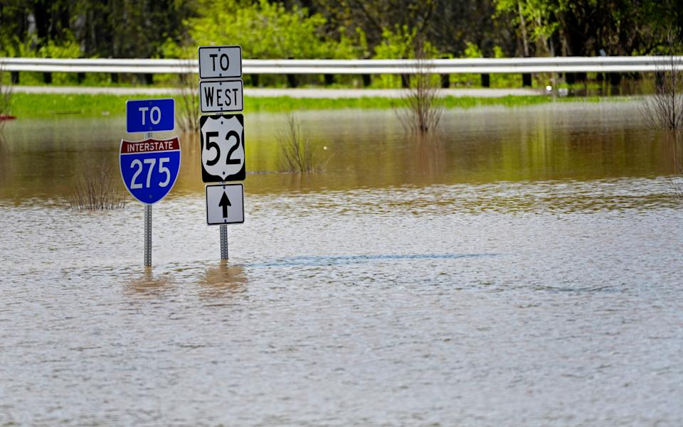
Stretches of U.S. Route 52 are expected to become flooded, along with additional low-lying roads near the river, and backwater flooding is expected along the Little Miami, Great Miami and Licking rivers, forecasters said. The main levels of homes in the East End could also become flooded.
The moderate flood stage begins at 56 feet, and the major flood stage begins at 65 feet. However, the NWS states that the river level is supposed to fall below the flood stage by Friday.
When will the Ohio River crest in Cincinnati?
The Ohio River is set to crest at just above 60 feet on Monday.
This article originally appeared on Cincinnati Enquirer: How the Ohio River levels compare to the all-time Cincinnati record
National Weather Service, Ohio River, Cincinnati, Licking River, river levels, flooded roads
#Ohio #River #levels #compare #Cincinnati #record #Theyre #ways